Examples of conformal maps with transform functions for field lines and potentials.

The Craft of Conformal Maps

Somewhere, within the craft of conformal maps, lie the answers to dark, difficult problems of physics.

For instance, can you map out the electric field lines around one of Benjamin Franklin’s pointed lightning rods?

Can you calculate the fluid velocities in a channel making a sharp right angle?

Now take it up a notch in difficulty: Can you find the distribution of the sizes of magnetic domains within a flat magnet that is about to depolarize?

Or take it to the max: Can you find the vibration frequencies of the cosmic strings of string theory?

The answers to all these questions starts with simple physics solutions within simple boundaries—sometimes a problem so simple even a freshman physics student can solve it—and then mapping the solution, point by point, onto the geometry of the desired problem.

Once the right mapping function is found, you can solve some of the stickiest, ugliest, crankiest problems of physics like a pro.

The Earliest Conformal Maps

What is a conformal map?  It is a transformation that takes one picture into another, keeping all local angles unchanged, no matter how distorted the overall transformation is.

This property was understood by the very first mathematicians, wrangling their sexagesimal numbers by the waters of Babylon as they mapped the heavens onto charts to foretell the coming of the seasons.

Sterographic projection of the celestial sphere onto a plane
Fig. 1 Geometry of stereographic projection

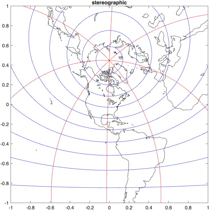
Hipparchus of Rhodes, around 150 BCE during the Hellenistic transition from Alexander to Caesar, was the first to describe the stereographic projection by which the locations of the stars were mapped on a plane by locating all the stars on the celestial sphere and tracing a line from the bottom of the sphere to the star and plotting where the line intersects the mid plane.  Why this method should be conformal, preserving the angles, was probably beyond his mathematical powers, but he probably intuitively knew that it did.

Astrolabe map of the stars based on stereographic projection
Fig. 2 An astrolabe for the location of Brussels, Belgium, generated by a stereographic projection

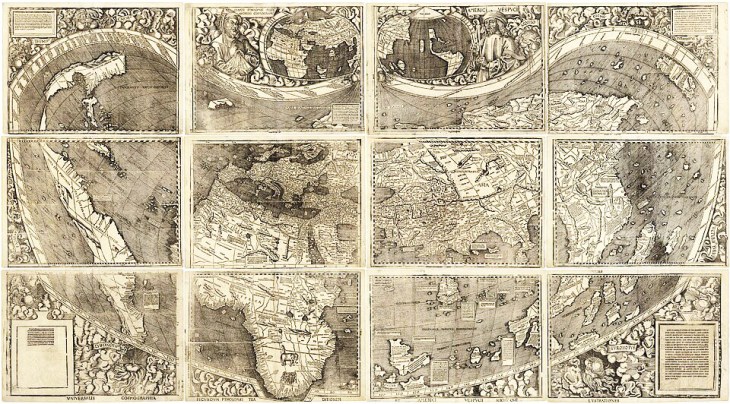
Ptolemy of Alexandria around 150 CE, expanded on Hipparchus’ star charts and then introduced his own conical-like projection to map all the known world of his day.  The Ptolemaic projection is almost conformal, but not quite.  He was more interested in keeping areas faithful than angles.

Ptolemy's map of the world as reconstructed in the Renaissance.
Fig. 3 A Renaissance rendering of Ptolemy’s map of the known world in pseudo-conic projection.

Mercator’s Rules of Rhumb

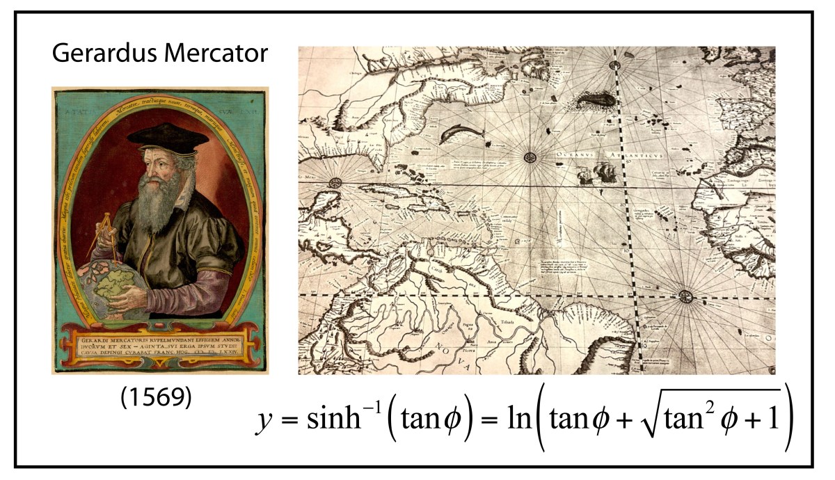
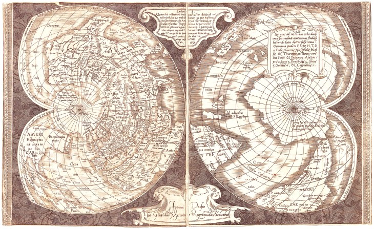
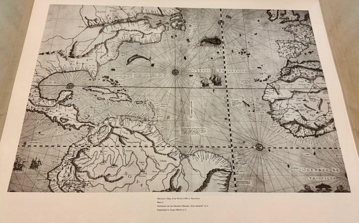
The first conformal mapping of the Earth’s surface onto the plane was constructed by Gerard Mercator in 1569.  His goal, as a map maker, was to construct a map that traced out a ship’s course of constant magnetic bearing as a straight line, known as a rhumb line.  This mapping property had important utility for navigators, especially on long voyages at sea beyond the sight of land, and was a hallmark of navigation maps of the Mediterranean, known as Portolan Charts.  Rhumb lines were easy to draw on the small scales of the middle ocean, but on the scale of the Earth, no one knew how to do it.

Mercator's North Atlantic map
Fig. 4 Mercator’s North Atlantic with compass roses and rhumb lines. (Note the fictitious islands south of Iceland and the large arctic continent north of Greenland.)

Though Mercator’s life and career have been put under the biographer’s microscope numerous times, the exact moment when he realized how to make his map—the now-famous Mercator Projection—is not known.  It is possible that he struck a compromise between a cylindrical point projection, that stretched the arctic regions, and a cylindrical line projection that compressed the arctic regions.  He also was a maker of large globes on which rhumb lines (actually curves) could be measured and transferred to a flat map.  Either way, he knew that he had invented something entirely new, and he promoted his map as an aid for the Age of Exploration.  There is some evidence that Frobisher took Mercator’s map with him during his three famous arctic expeditions seeking the Northwest Passage.

Mercator projection of the Earth
Fig. 5 Modern Mercator conformal projection of the Earth.

Mercator never explained nor described the mathematical function behind his projection.  This was first discovered by the English mathematician Thomas Harriot in 1589, 20 years after Mercator published his map, as Harriot was helping Sir Walter Rayleigh with his New World projects.  Like most of what Harriot did during his lifetime, he was years (sometimes decades) ahead of anyone else, but no one ever knew because he never published.  His genius remained buried in his personal notes until they were uncovered in the late 1800’s long after others had claimed credit for things he did first.

The rhumb lines of Mercator’s map maintain constant angle relative to all lines of longitude and hence the Mercator projection is a conformal map.  The mathematical proof of this fact was first given by James Gregory in 1668 (almost a century after Mercator’s feat) followed by a clearer proof by Isaac Barrow in 1670.  It was 25 years later that Edmund Halley (of Halley’s Comet fame) proved that the stereographic projection was also conformal.

A hundred years passed after Halley before anyone again looked into the conformal properties of mapping—and then the field exploded.

The Rube in Frederick’s Berlin

In 1761, the Swiss contingent of the Prussian Academy of Sciences nominated a little-known self-taught Swiss mathematician to the membership of the Academy.  The process was pro forma, but everyone nominated was interviewed personally by Frederick the Great who had restructured the Academy years before from a backwater society to a leading scientific society in Europe.  When Frederick met Johann Lambert, he thought it must be a practical joke.  Lambert looked strange, dressed strangely, and his manners were even stranger.  He was born poor, had never gone to school, and he looked it and he talked it. 

Portrait of Johann Heinrich Lambert
Fig. 6 Portrait of Johann Heinrich Lambert

Frederick rejected the nomination.

But the Swiss contingent, led by Leonhard Euler himself, persisted, because they knew what Frederick did not—Lambert was a genius.  He was an autodidact who had pulled himself up so thoroughly, that he had self-published some of the greatest works of philosophy and science of his generation.  One of these was on the science of optics which established standards of luminance that we still use today.  (In my own laboratory, my students and I routinely refer to Lambertian surfaces in our research on laser speckle.  And we use the Lambert-Beer law of optical attenuation every day in our experiments.)

Frederick finally relented after a delay of two years, and admitted Lambert to his Academy, where Lambert went on a writing rampage, publishing a paper a month over the next ten years, like a dam letting loose.

One of Lambert’s many papers was on projection maps of the Earth.  He not only picked up where Halley had left off a hundred years earlier, but he invented 7 new projections, three of which were conformal and four of which were equal area.  Three of Lambert’s projections are in standard use today in cartography

The Lambert conformal conic projection of the Earth
Fig. 7 The Lambert conformal conic projection centered on the 36th parallel.

Although Lambert worked at the time of Euler, Euler’s advances in complex-valued mathematics was still young and not well known, so Lambert worked his projections using conventional calculus.  It would be another 100 years before the power of complex analysis was brought fully to bear on the problem of conformal mappings.

Riemann’s Sphere

It seems like the history of geometry can be divided into two periods: the time before Bernhard Riemann and the time after Bernhard Riemann

Bernhard Riemann portrait
Fig. 8 Bernhard Riemann.

Bernhard Riemann was a gentle giant, a shy and unimposing figure with a Herculean mind.  He transformed how everyone thought about geometry, both real and complex.  His doctoral thesis was the most complete exposition to date on the power of complex analysis, and his Habilitation Lecture on the foundations of geometry shook those very foundations to their core.

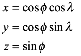
In the hands of Riemann, the stereographic projection became a complex transform of the simplest type

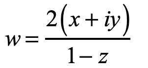
where x, y and z are the spherical coordinates of a point on the sphere.

Riemann sphere projection as a conformal map
Fig. 9 Conformal mapping of the surface of the Riemann sphere onto the complex plane.

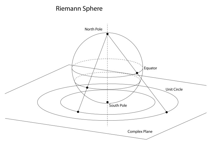
The projection in Fig. 9 is from the North Pole, which represents Antarctica faithfully but distorts the lands of the Northern Hemisphere. Any projection can be centered on a chosen point of the Earth by projecting from the opposite point, called the antipode. For instance, the stereographic projection centered on Chicago is shown in Fig. 10.

Stereographic projection centered on Chicago.
Fig. 10 Stereographic projection centered on Chicago, Illinois. Note the size of Greenland relative to its size in the Mercator projection of Fig. 5.

Building on the work of Euler and Cauchy, Riemann dove into conformal maps and emerged in 1851 with one of the most powerful theorems in complex analysis, known as the Riemann Mapping Theorem:

Any non-empty, simply connected open subset of the complex plane (which is not the entire plane itself) can be conformally mapped to the open unit disk. 

An immediate consequence of this is that all non-empty, simply connected open subsets of the complex plane are equivalent, because any domain can be mapped onto the unit disk, and then the unit disk can be mapped to any domain.

The consequences of this are astounding:  Solve a simple physics problem in a simple domain and then use the Riemann mapping theorem to transform it into the most complex, ugly, convoluted, twisted problem you can think of (as long as it is simply connected) and then you have the answer.

The reason that conformal maps (that are purely mathematical) allow the transformation of physics problems (that are “real”) is because physics is based on orthogonal sets of fields and potentials that govern how physical systems behave.  In other words, the solution to the Laplacian operator on one domain can be transformed to a solution of the Laplacian operator on a different domain.

Powerful! Great!  But how do you do it?  Riemann’s theorem was an existence proof—not a solution manual.  The mapping transformations still needed to be found.

Schwarz-Christoffel

On the heels of Bernard Riemann, who had altered the course of geometry, Hermann Schwarz at the University of Halle, Germany, and Elwin Bruno Christoffel at the Technical University in Zürich, Switzerland, took up Riemann’s mapping theorem to search for the actual mappings that would turn the theorem from “nice to know” to an actual formula.

Working independently, Christoffel in 1867 drew on his expertise in differential geometry while Schwarz in 1869 drew on his expertise in the calculus of variations, both with a solid background in geometry and complex analysis.  They focused on conformal maps of polygons because general domains on the complex plane can be described with polygonal boundaries.  The conformal map they sought would take simple portions of the complex plane and map them to the interior angle of a polygonal vertex.  With sufficient constraints, the goal was to map all the vertexes and hence the entire domain.

The surprisingly simple result is known as the Schwarz-Christoffel equation

where a, b, c … are the positions of the vertices, and α, β, γ … are the interior angles of the vertices.  The integral needs to be carried out on the complex plane, but it has closed-form solutions for many common cases.

This equation solves the problem of “how” that allows any physics solution on one domain to be mapped to another domain.

Conformal Maps

The list of possible conformal maps is literally limitless, yet there are a few that are so common that they deserve to be explored in some detail here.

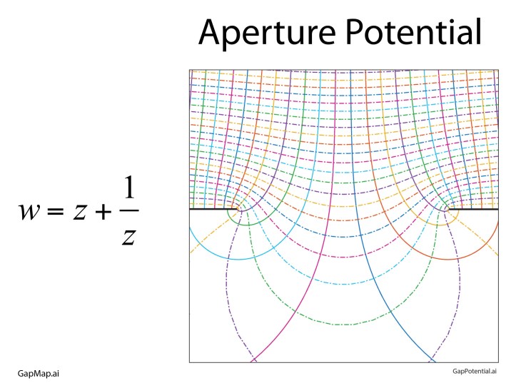
One conformal map is so “famous” it has the name of the Joukowski Map that takes the upper half plane and transforms it (through an open strip) onto the full complex plane. The field lines and potentials are shown in Fig. 11 as a simple transform of straight lines. To calculate these fields and potentials directly would require the solution of a partial differential equation (PDE) through numerical methods.

Field and potential lines near an aperture in conducting plates by a conformal map.
Fig. 11 Field lines and potentials around a gap in a charged conductor by the Joukowski conformal map.

Other common conformal maps are power-law transformations, taking the upper half plane into the full plane. Fig. 12 shows three of these, the first an inner half corner, the second the outer half corner, and the third transforming the upper half plane onto the full plane. All three of these show the field lines and the potentials near charged conducting plates.

Conformal maps from the half-plane to the full plane  with field and potential lines.
Fig. 12 Maps from the half-plane to the full plane: a) Inner corner, b) outer corner, c) charged thin plate.

Conformal maps can also be “daisy-chained”. For instance, in Fig. 13, the unit circle is transformed into the upper half plane, providing the field lines and equipotentials of a point charge near a conducting plate. The fields are those of a point charge and its image charge, creating a dipole potential. This charge and its image are transformed again into the fields and potentials of a point charge near a conducting corner.

Compound conformal maps of the unit circle to the half-plane to the outside of a corner.
Fig. 13 Point charge fields and potentials near a conducting corner by a compound conformal map: a) Unit circle to the half-plane, b) Half-plane to the outside corder.

But we are not quite done with conformal maps. They have reappeared in recent years in exciting new areas of physics in the form of conformal field theory.

Conformal Field Theory

The importance being conformal extends far beyond solutions to Laplace’s equation.  Physics is physics, regardless of how it comes about and how it is described, and transformations cannot change the physics.  As an example, when a many-body system is at a critical point, then the description of the system is scale independent.  In this case, changing scale is one type of transformation that keeps the physics the same.  Conformal maps also keep the physics the same by preserving angles.  Taking this idea into the quantum realm, a quantum field theory of a scale-invariant system can be conformally mapped onto other, more complex systems for which answers are not readily derived. 

This is why conformal field theory (CFT) has become an important new field of physics with applications ranging as widely as quantum phase transitions and quantum strings.


Books by David Nolte at Oxford University Press
Read more in Books by David D. Nolte at Oxford University Press.

Magister Mercator Maps the World (1569)

Gerardus Mercator was born in no-man’s land, in Flanders’ fields, caught in the middle between the Protestant Reformation and the Holy Roman Empire.  In his lifetime, armies washed back and forth over the countryside, sacking cities and obliterating the inhabitants.  At age 32 he was imprisoned by the Inquisition for heresy, though he had committed none, and languished for months as the authorities searched for the slimmest evidence against him.  They found none and he was released, though several of his fellow captives—elite academicians of their day—met their ends burned at the stake or beheaded or buried alive. It was not an easy time to be a scholar, with you and your work under persistent attack by political zealots.

Mercator received the degree of Magister, the degree in medieval universities that is equivalent to a Doctor of Philosophy … and then took what today we would call a “gap year” to “find himself” …

Yet in the midst of this turmoil and destruction, Mercator created marvels.  Originally trained for the Church, he was bewitched by cartography at a time when the known world was expanding rapidly after the discoveries of the New World.  Though the cognoscenti had known that the Earth was spherical since long before the Greeks, everyone saw it as flat, including cartographers, who in practice had to render it on flat maps.  When the world was local, flat maps worked well.  But as the world became global, new cartography methods were needed to capture the sphere, and Mercator entered the profession at just the moment when cartography was poised for a revolution.

Gerardus Mercator

The life of Gerardus Mercator (1512 – 1594) spanned nearly the full 16th century.  He was born 20 years after Colombus’ first voyage, and he died as Galileo began to study the law of fall, as Kepler began his study of planetary motion, and as Shakespeare began writing Romeo and Juliet.  Mercator was born in the town of Rupelmonde, Flanders, outside of Antwerp in the southern part of the Netherlands ruled by Hapsburg Spain.  His father was a poor shoemaker, but his uncle was an influential member of the clergy who paid for his nephew to attend a famous local school, in ‘s-Hertogenbosch, one where the humanist philosopher Erasmus (1466 – 1536) had attended several decades earlier. 

Mercator entered the University of Leuven in 1530 in the humanities where his friends included Andreas Vesalius (the future famous anatomist) and Antoine Granvelle (who would become one of the most powerful Cardinals of the era).  Mercator received the degree of Magister, the degree in medieval universities that is equivalent to a Doctor of Philosophy, in 1532, and then took what today we would call a “gap year” to “find himself” because he was having doubts about his faith and his future in the clergy.  It was during his gap year that he was introduced to cartography by the Franciscan friar Franciscus Monachus (1490 – 1565) at the Mechelen monastery situated between Antwerp and Brussels.

Returning to the University of Leuven in 1534, he launched himself into the physical sciences of geography and mathematics, for which he had no training, but he quickly mastered them under the tutelage of the Dutch mapmaker Gemma Frisius (1508 – 1555) at the university.  In 1537 Mercator completed his first map, a map of Palestine that received wide acclaim for its accuracy and artistry, and (more importantly) it sold well.  He had found his vocation.

Early Cartography

Maps are among the oldest man-made textual artefacts, dating to nearly 7000 BCE, several millennia before the invention of writing itself.  Knowing where things are, and where you are in relation to them, is probably the most important thing to remember in daily life.  Texts are memory devices, and maps are the oldest texts. 

The Alexandrian mathematician Claudius Ptolemy, around 150 CE, compiled a list of all the known world in his Geografia and drew up a map to accompany it.  It survived through Arabic translation and became a fixture in early medieval Europe where it remained a record of virtually all that was known until Christopher Columbus ran into the Caribbean Islands in 1492 on his way to China. Maps needed to be redrawn.

A pseudo-conic projection of the Mediterranean attributed to Ptolemy.
Fig. 1. A 1482 reproduction of the map of Ptolemy from 150 BCE. The known world had not expanded much in 1000 years. There is no bottom to Africa (the voyage of Bartolomeu Dias around the Cape of Good Hope came 6 years later) and no New World (Columbus’s first voyage was 10 years off).

The first map to show the new world was printed in 1500 by the Castillan navigator Juan de la Cosa, who had sailed with Columbus three times. His map included the explorations of John Cabot to the northern coasts.   

Portolan map by Juan de la Cosa.
Fig. 2. Juan de la Cosa’s 1500 map showing the new world as a single landmass (dark green on the left). Europe, Africa and Asia are outlined in light lettering in the center and right.

De la Cosa’s map was followed shortly by the world map of Martin Waldseemüller who named a small part of Brazil “America” in honor of Amerigo Vespucci who had just published an account of his adventures along the coasts of the new lands. 

The Waldseemüller map of 1507
Fig. 3. The Waldseemüller map of 1507 using “America” to name a part of current-day Brazil.

Leonardo da Vinci went further and created an eight-octant map of the globe around 1514, calling the entire new landmass “America”, expanding on Waldseemüller’s use of the name beyond merely Brazil.

The gores of Leonardo's world.
Fig. 4. The eight-octant globe found in the Leonardo codex in England. The globe is likely not by Leonardo’s own hand, but by one of his followers created sometime after 1507. The detail has far less than on the Waldseemüller map, but it is notable because it calls all of the New World “America”.

In 1538, just a year after his success with his Palastine map, Mercator created a map of the world that showed for the first time the separation of the Americas into two continents, the North and the South, expanding the name “America” to its full modern extent.

Mercator's 1538 map of the world.
Fig. 5. Mercator’s 1538 World Map showing North America and South America as separate continents. This is a “double cordiform” projection, which is a modified conical projection onto an internal cone with the apex at the Poles and the base at the Equator. The cone is split along the international date line (long before that was created). The Arctic is shown as an ocean while the Antarctic is shown as a continent (long before either of these facts were known).

These maps by the early cartographers were not functional maps for navigation, but were large, sometimes many feet across, meant to be displayed to advantage on the spacious walls in the rooms of the rich and famous.  On the other hand, since the late Middle Ages, there had been a long-standing tradition of map making among navigators whose lives depended on the utility and accuracy of their maps.  These navigational charts were called Portolan Charts, meaning literally charts of ports or harbors.  They carried sheaves of straight lines representing courses of constant magnetic bearing, meaning that the angle between the compass needle and the direction of the boat stayed constant. These are called rhumb lines, and they allowed ships to navigate between two known points beyond the sight of land.  The importance of rhumb lines far surpassed the use of decorative maps.  Mercator knew this, and for his next world map, he decided to give it rhumb lines that spanned the globe.  The problem was how to do it.

Portolan chart of the central Mediterranean.
Fig. 6. A Portolan Chart of the Mediterranean with Italy and Greece at the center, outlined by light lettering by the names of ports and bays. The straight lines are rhumb lines for constant-bearing navigation.

A Conformal Projection

Around the time that Mercator was bursting upon the cartographic scene, a Portuguese mathematician, Pedro Nunes, was studying courses of constant bearing upon a spherical globe.  These are mathematical paths on the sphere that were later called loxodromes, but over short distances, they corresponded to the rhumb line. 

Thirty years later, Mercator had become a master cartographer, creating globes along with scientific instruments and maps.  His globes were among the most precise instruments of their day, and he learned how to draw accurate loxodromes, following the work of Nunes.  On a globe, these lines became “curly cues” as they approached a Pole of the sphere, circling around the Pole in ever tighter circles that defied mathematical description (until many years later when Thomas Harriot showed they were logarithmic spirals).  Yet Mercator was a master draftsman, and he translated the curved loxodromes on the globe into straight lines on a world map.  What he discovered was a projection in which all lines of Longitude and all lines of Meridian were straight lines, as were all courses of constant bearing.  He completed his map in 1569, explicitly hawking its utility as a map that could be used on a global scale just as Portolan charts had been used in the Mediterranean.

Map of the North Atlantic by Gerard Mercator.
Fig. 7. A portion of Mercator’s 1569 World Map. The island just south of Thule (Iceland) is purely fictitious. Mercator has also filled in the Arctic Ocean with a new continent.
A segment of Mercator's 1569 map of the world.
Fig. 8. The Atlantic Ocean on Mercator’s 1569 map. Rhumb lines run true at all latitudes.

Mercator in 1569 was already established and famous and an old hand at making maps, yet even he was impressed by the surprising unity of his discovery.  Today, the Mercator projection is called a conformal map, meaning that all angles among intersecting lines on the globe are conserved in the planar projection, explaining the linear longitudes, latitudes and rhumbs.

The Geometry of Gerhardus Mercator

Mercator’s new projection is a convenient exercise in differential geometry. Begin with the transformation from spherical coordinates to Cartesian coordinates

where λ is the longitude and φ is the latitude. The Jacobian matrix is

Taking the transpose, and viewing each row as a new vector

creates the basis vectors of the spherical surface

A unit vector with constant heading at angle β is expressed in the new basis vectors as

and the path length and arc length along a constant-bearing path are related as

Equating common coefficients of the basis vectors gives

which is solved to yield the ordinary differential equation

This is integrated as

which is a logarithmic spiral.  The special function is called “the inverse Gundermannian”.  The longitude λ as a function of the latitude φ is solved as

To generate a Mercator rhumb, we only need to go back to a new set of Cartesian coordinates on a flat map

It is interesting to compare the Mercator projection to a conical projection onto a cylinder touching the sphere at its equator where the Mercator projection is

Equation for the Mercator projection.

while the conical projection onto the cylinder is

Clearly, the two projections are essentially the same around the Equator, but deviate exponentially approaching the Poles.

The Mercator projection has the conformal advantage, but it also has the disadvantage that landmasses at increasing latitude increase in size relative to their physical size on the glove.  Therefore, Greenland looks as big as Africa on a Mercator projection, while it is in fact only about the size of Texas.  The exaggerated sizes of countries in the upper latitudes (like the USA and Europe) relative to tropical countries near the equator has been viewed as creating an unfair psychological bias of first-world countries over third-world countries.  For this reason, Mercator projections are virtually never used today, with other map projections that retain relative sizes being now the most common. 

References


Crane, N. (2002), Mercator: The Man who Mapped the Planet, Weidenfeld & Nicolson, London.


Kythe, P. K. (2019), Handbook of Conformal Mappings and Applications, CRC Press.


Monmonier, M. S. (2004), Rhumb Lines and Map Wars: A Social History of the Mercator Projection, University of Chicago Press.


Snyder, J. P. (2002), Flattening the earth: Two thousand years of map projections, 5. ed ed., The University of Chicago Press, Chicago

Taylor, A. (2004), The World of Gerard Mercator: The Mapmaker Who Revolutionized Geography, Walker & Company, New York.

Read more in Books by David D. Nolte at Oxford University Press